")
Part II – Managing India’s Water Crisis expeditiously is Existential, and how can India deter China from her water hegemon actions in Tibet
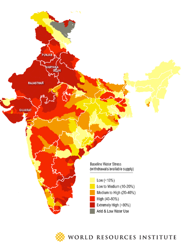
India, a water scarce country
India is in the UN’s Global Drought Vulnerability Index. India’s drought-prone area has increased by 57 percent since 1997. Drought has affected nearly two-thirds of the country from 2020 to 2022. Over the last decade, one-third of India’s districts have experienced more than four droughts, and drought affects 50 million people each year. China and Nepal are upper riparian states for India, which has geo-strategic-political compulsions.
Water Management is a strategic imperative for water scarce India
Water Statistics are Truly Alarming
As per Dr Rajiv Kumar, ex Vice Chairman, National Institution for Transforming India (NITI Aayog), in August 2021, the annual available water after evapotranspiration[i] is 1999 billion cubic metres (bcm), of which the utilizable water potential is estimated at 1122 bcm. India is the largest groundwater user in the world, with an estimated usage of around 251 bcm per year, more than a quarter of the global total. With more than 60 per cent of irrigated agriculture and 85 per cent of drinking water supplies dependent on it, and growing industrial/urban usage, groundwater is a vital resource. It is projected that the per capital water availability will dip to around 1400 cum in 2025, and further down to 1250 cum by 2050. A report titled “Composite Water Management Index (CWMI)”[ii], published by NITI Aayog in June 2018, mentioned that India was undergoing the worst water crisis in its history; that nearly 600 million people were facing high to extreme water stress; and about 200,000 people were dying every year due to inadequate access to safe water. The report further mentioned that India was placed at the rank of 120 amongst 122 countries in the water quality index, with nearly 70 per cent of water being contaminated. It projected the country’s water demand to be twice the available supply by 2030, implying severe scarcity for hundreds of millions of people and an eventual loss in the country’s GDP[iii]. Vitally, food security is at risk, given that large agricultural producers (states) are struggling to manage their water resources effectively. On the positive side, greater focus on water governance and increased data discipline amongst states is building a pathway for driving long-term success.
Even good Monsoons cannot solve India’s water crisis: About 600m Indians (more than 40% of the population), rely on agriculture for their living. A little over half of the country’s farmland is not irrigated, but are watered by the rains. Climate change has made monsoon patterns erratic; for instance, this year Kolkata went 61 days without rain, its longest stretch since 2000. Heavy rain does not penetrate and irrigate the soil, but erodes it, damaging farmland rather than helping crops to flourish. That India’s rainfall is concentrated into shorter periods also means that dry spells are lengthier. That encourages Indians to use groundwater to preserve their crops. Interestingly, a law passed in 1882 gives every landowner the right to use the water under their land as they choose. While the “Green Revolution” made the country a net food exporter, it also led to the widespread construction of tube wells. India now pumps more groundwater than America and China put together. Last year a study in Science Advances found that by 2025 large portions of north-western and southern India will have “critically low groundwater availability.” [iv]
The Government is moving but very slowly
For scientific management of water ecosystem, the Ministry of Jal Shakti (by merging the Ministry of Water Resources, River Development & Ganga Rejuvenation, and Ministry of Drinking Water and Sanitation) was created in May 2019 to consolidate interrelated functions pertaining to water management. It has earmarked $45bn (INR 3.6 trillion) on the Jal Jeevan Mission (JJM) to provide safe drinking water to all rural households by 2024. JJM focuses on 1592 water-stressed blocks in 256 districts. Mission is to provide 55 litres of piped water supply per person to every household through the Functional Household Tap Connections scheme with concurrent mandatory source sustainability measures. Primary focus is on 97 lakh households in five priority states of Assam, Bihar, Tamil Nadu, Uttar Pradesh and West Bengal [due to increase in water borne diseases including Acute Encephalitis Syndrome (AES)]. By working together with the health, education, social justice and housing ministries, the Water Ministry hopes to reduce AES morbidity and mortality. JJM Highlights are at Note(v).
Other State and Non-State Measures
Large number of hydroelectrical projects are being taken up in Arunachal Pradesh as run-of-river schemes and would have very negligible impact in triggering floods in downstream areas. Unfortunately, this necessary construction has got embroiled in an incorrect narrative and become a weapon of geopolitics. A mass movement engineered by the Assam-based Krishak Mukti Sangram Samiti (KMSS) has demanded a stop to all mega dam projects in the country’s sensitive Northeast. While some of their apprehensions are legitimate, the fact is that this water would not only be a power reservoir for the region, but also for the rest of India. The protest that began in Assam, led by the KMSS, against the construction of mega dams is leading to a conflict between development and environment protection. It is recommended that a feasibility study of the schemes that are being planned must be taken up for the Lohit basin by the Ministry of Environment, Forest, and Climate Change.
Meanwhile in Punjab, one of India’s leading wheat-producing states (UP is topping the chart last two years with 33% and Punjab 16%), several schemes provide farmers with cash incentives to pump less groundwater. Some states use techniques that are centuries old, harvesting run-off from monsoons and building dams to help replenish groundwater. These traditional efforts may prove more effective than sweeping national schemes, which are hampered by graft and bickering among state governments. India is ‘going digital’, with around 6,000 sensors being installed across India to gather data on lakes, reservoirs and rivers. Another 1,600 sensors will track underground water. All will be connected to the mobile phone network and will transmit real-time data, including water levels and weather conditions such as rainfall, humidity and air pressure. This data will be available on one centralised, web-based system so anyone can use it. Meanwhile software is being developed that can analyse that data and make it useful to decision makers. Marcella D’Souza from the Watershed Organisation Trust says such local projects are the key to managing India’s water resources. “The water situation is complex and no single agency can handle it alone,” she concludes “It is the responsibility of the local community and gram panchayats [village councils] to share the resources, to work together to protect their precious water resource. They need to be empowered with knowledge so as to make informed decisions.”
China-India Riparian States: Chinese actions on Tibet Autonomous Region Rivers specially Yarlung Tsangpo and Implications for India
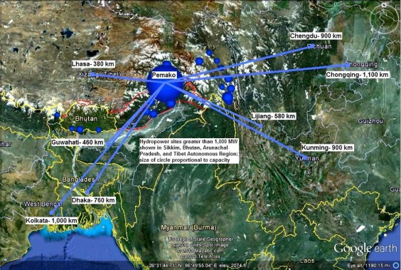
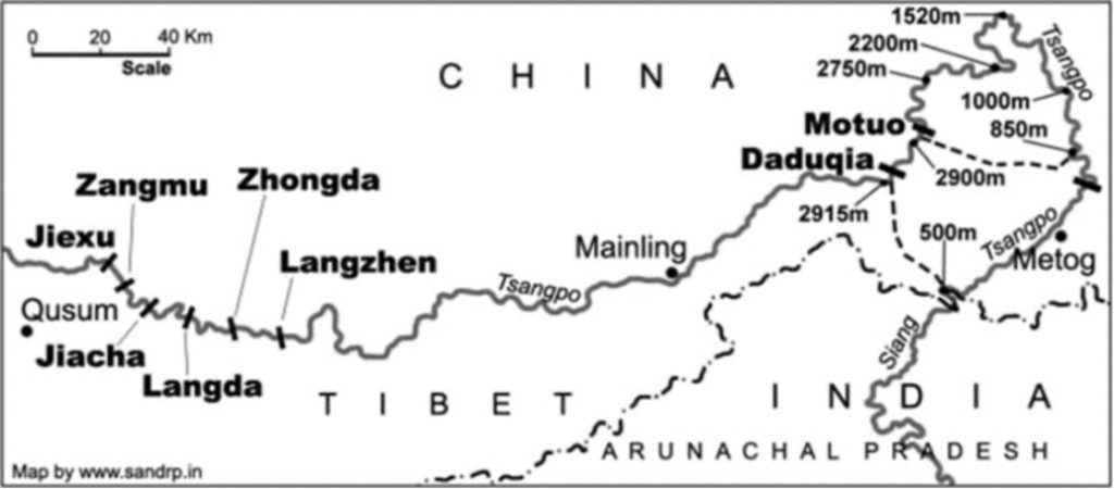
This paragraph is a recapitulation of what was written in Part I. The damming of the Brahmaputra started during November 2010, with the 7.9 billion RMB 3260-meter Zangmu Hydropower Station 510 MW, which became fully operational on October 13, 2015. China has undertaken a huge project to construct five dams in Shannan Prefecture in the Tibet Autonomous Region (TAR). The precise locations of the project are reportedly in Gyatsa, Jieuxu, Langzhen, Zangmu, and Zhongda in the TAR. The dams are slated to divert the waters of the Brahmaputra River (Yarlung-Tsangpo in Tibet) to China’s water-scare North-western and Northern provinces. China adopted its 14th Five-Year Plan, which included a blueprint amounting to billions of dollars’ worth of projects, including controversial hydropower projects on the Brahmaputra in the TAR. China is embarking upon ambitious “dam-constructing exercises” on all its important rivers. The familiar Three Gorges Project across the Yangtze River is one such project.[vi]
Importance of River Brahmaputra to India: Apart from providing existential water to India, River Brahmaputra also provides–
- Hydroelectricity. According to the Central Electricity authority, the Brahmaputra River basin possesses about 44 per cent of India’s total hydropower potential. It is assessed that the ‘exploitable hydropower potential’ of the Brahmaputra basin is 58,356 MW out of the overall hydro-electric potential of India estimated to be around 150,000 MW.
- Means of Livelihood: Obvious and not being elaborated.
- Inland River Waterways: It has immense potential of providing easy and cheap communication networks and accessibility within the North-eastern states and also up to Chittagong in Bangladesh.
Should the lower Riparian States especially India be Worried?
The plan to divert the waters of Brahmaputra would affect over 140 million people who are dependent on the river. Indeed, it would be India and Bangladesh that would have to bear the brunt of the planned damming and diversion. There is great apprehension that the diversion of the waters would affect the downstream flow in Northeast India and beyond. Li Chaoyi, the chief engineer of China Huaneng Group, which is the prime contractor of the dam project, said that the river’s flow would not be affected by the construction of the dam. Quoted in the official Chinese news agency, Xinhua, Li stated, “After it becomes operational, the river water will flow downstream through water turbines and sluices. So, the water volume downstream will not be cut.” He also stated that environmental protection would be a priority. Nevertheless, the issue of the dam remains a cause of great concern for India and has been taken up at the highest levels including the Foreign Secretary level since 2010.
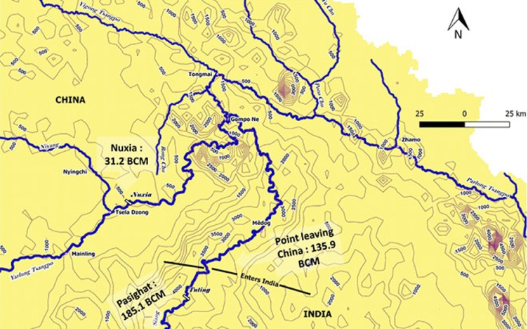
Experts have concluded that hydrology and precipitation over the Yarlung Tsangpo/Brahmaputra are highly correlated, and in fact the contribution of snow and glacial melt to the flow is substantially low in the overall stretch; however, its contribution is higher in the upper reaches of the flow which are in the rain-shadow region. Of the total 2,880 kilometres (k.m.) length of the Yarlung Tsangpo/ Brahmaputra, 1,625 k.m. flows through the Tibetan plateau with the name Yarlung Tsangpo, whereas it assumes the names of Siang, Dihang, and Brahmaputra in its 918 k.m. in India, and the rest of the 337 k.m. in Bangladesh is named the Jamuna till its confluence with the Ganges near Goalando. Though this geographical distribution of length gives an apparent impression that the maximum flow of the system occurs in the TAR (Tibet Autonomous Region) of China, it is a myth! Rather, the system becomes stronger and fatter as it flows further downstream. It needs to be noted here that the Brahmaputra is identified as the flow downstream of the confluence of three tributaries, namely the Luhit, Dibang, and Dihang, near Sadiya in the Indian state of Assam.[vii] While the peak flows at Nuxia and Tsela Dzong measuring stations at the great bend in the Tibetan plateau are about 5,000 and 10,000 cubic metres per second (cumecs), the peak flow at Guwahati in Assam is approximately 55,000 cumecs. Thus, as per one scientific interpretation; rainfall creates the flow and given the precipitation, run-off and sediment flow regimes, it is unlikely that any intervention on the Yarlung Tsangpo in the north region of the Himalaya can cause any substantial harm for downstream economies including India and Bangladesh, irrespective of Chinese intent.[viii]
However, the same cannot be stated for the present proposed project in the Medog county of Tibet Autonomous Region (TAR)
Indian research suggests that the region, entailing the Great Bend at the intersection of the basins of Yigong Tsangpo, Parlung Tsangpo, and the Lower Yarlung, exhibit events like high monsoonal precipitation, strong possibilities of landslides and avalanches leading to flash floods with the average annual frequency of such hazardous events being 10 or more. Further even Medog witnesses 12-15 such incidents on an average. The biggest concern is its unpredictable tectonicity as is prevalent in large parts of Eastern Himalayan system. Therefore, any such event resulting in any form of dam burst or otherwise can have disastrous impacts on the immediate downstream particularly Arunachal Pradesh which will most likely experience sudden flooding.
What can India Do?
There is no international law or mechanism where such a right can be defended against actions of upstream countries. Such a defence would be possible if there was a treaty on sharing the common rivers, like the Indus Treaty that India has with Pakistan. But no such treaty exists between India and China on any of the rivers that the two countries share. However, some strategists feel that India should refrain from any knee-jerk reaction specially in the current geo-political climate where trust levels are at its nadir. It could demolish years of progress that has been made by states in establishing mechanisms of hydro-diplomacy. A testament of this is the India-China Expert Level Mechanism (ELM) on Trans-border Rivers and the hydrological data (water level, discharge, and rainfall) sharing agreement that exists between India and China on the Yarlung/Brahmaputra and Langqen/Sutlej, which has continued despite the hostilities at the Line of Actual Control (there was lack of data for a very brief period only).
TS Mehra, a senior official in India’s federal water ministry, told the Reuters news agency, “The need of the hour is to have a big dam in Arunachal Pradesh to mitigate the adverse impact of the Chinese dam projects”. He added that this would create a large water storage capacity to offset the effect of Chinese dams on water flows. Moreover, China’s capability and, arguably, the intent to use water as a weapon when required is another aspect India has to be mindful of. India must evolve a strategic road map in concert with other lower riparian and like-minded states and international organisations to ensure that China adheres to the laid down principles, norms and rules on the sharing of trans-border rivers. It has to be ensured that China respects the interests and concerns of lower riparian nations before embarking on trans-border river projects, that have far-reaching and potentially catastrophic effects.[ix]
Conclusion
To achieve water security, there is no choice except to focus on rainwater harvesting, recharge of aquifers, proper storage, and efficient utilization. This conscious thought-process is to be developed in all stakeholders through education and awareness, working from schools and villages upwards. Apart from the JJM initiatives, NITI Aayog in October 2021 has released a compendium on the role of communities in water management, and lists out best practices on: agriculture; groundwater management; watershed development; water infrastructure; and climate risk and resilience. We also need to learn from other countries’ successes, such as Israel which has turned a water crisis into an opportunity even though it receives one-fourth of the rainfall we get in India. Israel is now water secure and its groundwater level is also increasing, due to the adoption of new techniques.
Undoubtedly, water is an existential resource, and many security and geo-political experts predict that unless fair and proper water management is ensured and agreed upon, it has the potential for confrontation between inter and intra states/nations. Apart from the border issue with China, water management in Tibet by China is likely to be a major confrontation point between the two nations. In fact, if both nations do not act responsibly and urgently to ensure water security, it could trigger conflict. For now, India needs to talk to China, coalesce support of affected nations like Bhutan, Bangladesh, Myanmar, Thailand and even Pakistan, as also draw on international support to prevent China from interfering with the flow of rivers in Tibet, which has the potential to cause man-made ecological disasters. In a country that has 18% of the world’s population but just 4% of its water, every drop counts.
[i] Evapotranspiration – the process by which water is transferred from the land to the atmosphere by evaporation from the soil and other surfaces and by transpiration from plants.
[ii] The CWMI was conceptualized as a tool to instil a sense of cooperative and competitive federalism among the states. This was a first-ever attempt at creating a pan-India set of metrics that measured different dimensions of water management and use across the lifecycle of water. The water data collection exercise was carried out in partnership with the Ministry of Jal Shakti, Ministry of Rural Development, and all the States/Union Territories (UTs). The report was widely acknowledged and provided guidance to States on their success areas, absolutely and relatively, and on recommendations to secure their water future. CWMI 2.0, released in August 2019, ranked various states for the reference year 2017–18 as against the base year 2016–17. Gujarat held on to its first rank in 2017–18, followed by Andhra Pradesh, Madhya Pradesh, Goa, Karnataka, and Tamil Nadu. Amongst North Eastern and Himalayan States, Himachal Pradesh was adjudged on top. The UTs submitted their data for the first time, with Puducherry declared the top ranker. On an average, 80 per cent of the states assessed on the Index over the last three years have improved their water management scores, with an average improvement of +5.2 points. But worryingly, 16 out of the 27 states still score less than 50 points on the Index (out of 100), and fall in the low-performing category. These states collectively account for ~48 per cent of the population, ~40 per cent of agricultural produce, and ~35 per cent of the economic output of India. Uttar Pradesh, Rajasthan, Kerala, and Delhi, 4 of the top 10 contributors to India’s economic output and accounting for over a quarter of India’s population, have scores ranging from 20 points to 47 points on the CWMI.
[v] JJM Highlights (Source: Teri Report)
As per a comprehensive report released on October 2, 2021, the following are the major achievements since 2019:
1. 8.26 crore (43 per cent) rural households (in over 1.16 lakh villages and 79 districts) are getting tap water supply in their homes.
2. 5.03 crore tap water connections provided since the JJM launch.
3. Goa, Haryana, Telangana, A&N Islands, Daman & Diu, Dadra & Nagar Haveli, and Puducherry have achieved ‘Har Ghar Jal’.
4. 1.22 crore (36.09 per cent) households in socio-economically backward districts are getting tap water supply in their homes, that is, about four times increase in coverage since JJM was announced.
5. 1.15 crore (37.83 per cent) households in 60 identified JE/AES endemic districts are getting tap water supply in their homes, that is, about 15 times increase in coverage since the announcement of JJM.
6. 3.43 lakh Village Water Sanitation Committees/Pani Samitis constituted/made functional.
7. 2.86 lakh Village Adoption Programmes by the National Institute of Food Technology.
8. Entrepreneurship and Management students, prepared and approved in different villages.
9. 7.93 lakh (76.93 per cent) schools and 7.65 lakh (68.21 percent) Anganwadi Centres provided with tap water connections.
Skilling
JJM provides huge employment opportunities in villages, to successfully implement the Mission and ensure long-term operation and maintenance of in-village water supply systems. To meet this present and future requirement, skilling is a major component to produce a good number of masons, plumbers, electricians, pump operators, etc. Development partners are being engaged by states to prepare modules for sensitization and capacity building in villages. Also, the COVID-19 pandemic has led to reverse migration of skilled and semi-skilled human resources, which can be turned into a mutually beneficial opportunity for the programme and employment opportunities in rural areas. Among the technological interventions, a modern, public, online ‘JJM— Integrated Management Information System’ has been set up for day-to-day planning, implementation, monitoring, and reporting of the national/State/UT/district/village-level progress. Furthermore, to ensure transparency and modern fund management, a Public Finance Management System has been made compulsory under JJM.
(This article was first published in CENJOWS)